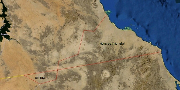
Sudan includes Halayeb triangle as baseline to measure maritime borders

April 21, 2017 (KHARTOUM) – The Sudanese government has deposited with the United Nations (UN) the coordinates of the baselines from which its maritime areas are measured, including the disputed Halayeb triangle with Egypt.
The Halayeb triangle, which is a 20,580 km area on the Red Sea, has been a contentious issue between Egypt and Sudan since 1958, shortly after Sudan gained its independence from the British-Egyptian rule in January 1956.
The area has been under Cairo’s full military control since the mid-1990’s following a Sudanese-backed attempt to kill the former Egyptian President Mohamed Hosni Mubarak.
On 2 March, President Omer al-Bashir issued a decree including the baselines from which the maritime areas of the Republic of Sudan are measured.
By virtue of its membership in the UN Convention on the Law of the Sea, Sudan is required to notify the UN Secretary-General of any development affecting the geography of its maritime boundary.
In conjunction with the notification, the Sudanese foreign ministry deposited with the UN its reservation on a similar decree issued by former Egyptian President Hosni Mubarak in 1990, in which he laid the baselines for the Egyptian maritime areas.
“The Republic of the Sudan declares its rejection and refusal to recognize the provisions of the declaration issued by the Arab Republic of Egypt on 9 January 1990, entitled Presidential Decree No. 27, which touches on the Sudanese maritime border, North of Line 22, which was included within the maritime coordinates announced by Egypt within its maritime borders on the Red Sea in paragraphs 56-60,” read Sudan’s declaration seen by Sudan Tribune.
“The above points (in Mubarak’s decree of 1990) are located within the maritime boundaries of Sudan’s Halayeb triangle which falls under Egyptian military occupation since1995 to date, and thus are part of the Sudanese maritime border on the Red Sea” added the declaration.
The foreign ministry stressed that the Halayeb triangle is a Sudanese territory located within the political and geographic borders of the Sudan, saying these borders have been recognised internationally during the various historical periods, including the period of the British-Egyptian condominium colonisation.
It underscored that Sudan inherited these borders since its independence was declared in 1956, saying this fact is supported by the UN records and maps and wasn’t disputed by any party.
The foreign ministry pointed out that Sudan has been notifying the UN Security Council on this issue annually since 1958 until 5 January 2017 “in order to renew its rejection of the Egyptian military occupation of Sudan’s Halayeb triangle and maritime borders”.
“As well as to renew its non-recognition of all sovereign actions by the Egyptian government in the Halayeb triangle and maritime borders on the basis of the current situation,” it added.
Last April, Cairo refused a demand by the Sudanese government to hold direct talks on Halayeb and Shalateen or to accept the referral of the dispute to the International Court of Arbitration.
Egypt has used to reject Sudan’s repeated calls for referring the dispute to international arbitration.
The international law provides that the agreement of the two parties is needed to arbitrate a dispute by the tribunal.
(ST)
