
Juba to develop new map for southern Sudan territory
By James Gatdet Dak Lampuar
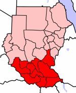
September 27, 2007 (JUBA) — The Government of Southern Sudan has resolved to develop a new working map for its territory. The working map will include the disputed territories, which were incorrectly annexed to northern Sudan in the current perceived 1956 North-South boundary.
 The decision was taken in a Council of Ministers meeting held on Wednesday, Juba, under the chairmanship of the Government of Southern Sudan’s President, Salva Kiir Mayardit, who also holds the post of the First Vice Presidency in the Government of National Unity.
The Council further resolved that the new map should also contain the original local names of rivers, villages, towns, etc, to replace some names, which are alien to the local population in Southern Sudan.
The resolution is backed up by an initial resolution passed early this year by the Governors of the ten Southern Sudan states in their ‘Governors Forum’ chaired by the Vice President, Riek Machar Teny. That resolution also called for a review of the map of Southern Sudan, including its internal States and Counties boundaries.
This working map, which may take less than a month to come out and become ready for use, will serve as an interim and comprehensive map for Southern Sudan territory, pending the completion of the work of demarcation of the boundary by the established North-South Boundary Commission.
The work of this Commission, which was established by the Presidency of the Government of National Unity, is set to be completed by the first quarter of 2008.
In a press statement shortly after the Council of Ministers passed the resolution, Samson Kwaje, the Government Spokesperson and Minister of Information and Broadcasting, said the Council also resolved to strengthen the membership of the Government of Southern Sudan’s component of the committee on the boundary commission. He added that the committee will also be strengthened financially so that it is able to speed up its work to meet its deadline.
Earlier this month, a British expert, Douglas H. Johnson, presented a public lecture on North-South boundaries in Juba after conducting an extensive research dating back to maps and descriptions of the original North-South boundary during the British colonial period.
Johnson was requested by the Presidency of the Government of Southern Sudan to conduct the research and present its findings to the Government.
His findings indicated that this incorrect North-South boundary of 1956 has taken some parts of Southern Sudan to Northern Sudan. The report indicated that the most contentious territories are in Upper Nile, Northern Bahr el Ghazal and Unity states.
The demarcation of the North-South boundary is key to implementation of several protocols in the January 2005 Comprehensive Peace Agreement. It has great bearing on redeployment of forces, wealth sharing, population census, general elections and the 2011 referendum.
(ST)
Toposa Boy southerner
Juba to develop new map for southern Sudan territory
Best S.S for the very first time our government in Juba doing something for us
Keep up good job Thank you can reach me by Email [email protected]
Holland/the Netherlands
Gatluak Latjor
Juba to develop new map for southern Sudan territory
Very good initiative from the GoSS side. This is a strong message to the NCP.The GoSS should add more like a universal TV for south Sudan.
Gatluak Latjor.
Jacque Chiengnyang de Mabor
Juba to develop new map for southern Sudan territory
One is profoundly mesmerised at hearing many fellow southerners boasting of sucession at the end of the six year interim period! The right of self determination granted to south sudanese by the glorious CPA can only but only be exercised and achieved when all the vitally important prerequisites have been exhaustively resolved.
The south-north border issue being the topping phenomenon in this regard requires a tough contention so that all the southern parts that have been forcefully/wrongly annexed to the north are restored back to the southern territory. Then it is only after this that we can claim an independent nation with clearly define d geographical territories and therefore can successfully vote for separation.
Another crucial prerequisite factor that can determine our fate in the upcoming referendum is population census. Without vividly known national demographic statistics, the voting exercise would be nothing than a futile activity where we do not know how many people there are.This can lead to vulnerability of the elections to rigging and rendering of any voting exercise invalid and null,simply because the population is not accurately counted or not known at all.
So now that the government of south sudan has commenced on the most important factor that will take us to our esteemed destiny of succession, this move should not go unappreciated. As I extend my heartfelt gratitudes towards this audacious move of prioritising this hotly controversial south-north borderline issue, I strongly urge my leaders to speed it up so that positive results are realised by the end of 2008; and to also press the census commission to expedite the population count soonest enough,otherwise our contention for separation will be absolutely without avail, if the aforementioned issues are not settled properly.
The struggle continues.
Jacque Chiengnyang de Mabor
Samson Liberty
Juba to develop new map for southern Sudan territory
It is now genuine that one major hope has been restored in Southern Sudan.this is to draw clear planning and developlemental progress in SS,and also that the meaning of New Sudan can now be realized.Wednesday 26 September,2007, to remain an Historical calender of Goss.Another thing people want to see the immediate withdrawal of SAF from rich oil fields according to CPA.People also want to see the speedy development of the SS map;because all these is vital for:census,elections and referundum in the intrim period.
mumo mutinda
Juba to develop new map for southern Sudan territory
This is a milestone archievement for our brotherly peolple is southern sudan. No rivers, mountains, cities districts, provinces and states should have Arabic names. This was the way of the Arabs to conqure, acculturize, Arabize and relagate our African brothers to the bottom of the cultural ladder. This nonsense from the arabs disregarding who we are and what is our has got to come to an end. Allien names have got to be errassed from maps.What is this nonsense called Bar-el-Ghazal state, Warab state, Nasir town, and many Arabic names in the heart of our lands.Didnt we have African names for these rivers , mountains, lakes,towns etc. I as a Kenyan i am saddened when i see the way these Arabs wanted to show the Africans in Sudan they are nothing and that the Arabic culture was the in-thing. Nonsense!. Africans in Sudan reclaim your pride, culture, names and your rightful place in Sudan.Sudan belongs to you.How can someone come from Arabia and start naming places in Arabic terms as if the places did not have indegenous names? It is just a pitty when i hear an African from Sudan calling himself silly Arabic names as if all his indegenous names got finished. this is what i call mental slavery, but thank you, our brothers from southern sudan for deciding to rectify these mistakes committed by the Arabs on the Africans. S.Africa is correcting all the names into African names not Afrikaans names, Zimbabwe did it,Mozambique changed all Portuguese names to local names.All African countries have done so. Why not our brothers from Southern Sudan. This is the way forward. We do not want to travel in Sudan and think we are in Saudi Arabia or the middle-East due to these abnormal Arabic name there.
kaci-banno
Juba to develop new map for southern Sudan territory
Nothing can make me excited for work of the map until the design of map get done first because there are some narrow minded leaders within the government of southern Sudan thinking only for their own locations to be written on the map. The government of southern Sudan has to be careful to assign right people to draft the Map of Southern Sudan.
By: Kaci-Ma-banno