
Jonglei canal project, a case of ecological imperialism
A Response to Vice President Taban Deng Gai’s public call for a resumption of the Jonglei Canal Project (2022) and Hon. Manawa Peter Gatkuoth’s (Minister of Water Resources and Irrigation) Plan for the Jonglei Canal Development Project (2021).
By Deng Majok Chol
DPh Candidate, Oxford University.
References are to Vice President Taban Deng Gai’s “call for the resumption of the Jonglei Canal to prevent flood disaster” in Jonglei, Unity, and Upper Nile states, published by Eye Radio correspondent, Koang Pal Chang, on February 28, 2022, and Hon. Manawa Peter Gatkuoth’s presentation, “Jonglei Canal Development Project” in December 2021. First, it is useful to provide some contexts of the complexity and fragility of the Sudd and the siad Jonglei Canal Project.
The Sudd is a story of a life cycle that revolves around its seasonality. Human life and biotic diversity rely on the Sudd water and environmental resources for survival and progression. The ongoing increase in flooding events is only a small fluctuation within the longer millennial cycle of the Sudd. Each of the preceding generations of the ethnic communities (Dinka, Nuer, Murle, Shilluk, Mundari, Anuak, Mabanes, Acholi among others) have had to grapple with the impacts of the fluctuation of water volume in the Nile and the Sudd, which is increasingly induced by climate change and variability. To look for sustainable solutions to the threats and impacts of the flooding through the intervention of largescale physical infrastructure, amidst the unique geopolitical circumstances and backdrops of the history of the Jonglei Canal, would be environmental imperialism (Katz 1995). Now that the Republic of South Sudan, due to celebrate her 11th birthday this year, is exhibiting a desire to exercise its sovereign rights over its water resources, my responses to both the VP Gai and Hon. Gatkuoth calls for a resumption of the Jonglei Canal should be a constructive critique, laid out as follows.
Key specific points from VP Gai’s and Hon. Gatkuoth’s calls.
- In his speech, VP Taban Deng Gai argued that “to avoid displacement caused by flooding, waterways should be opened by resuming the digging of the Jonglei Canal. He further added that “the digging of the Jonglei Canal that was stopped needs to be revised but should be done under our terms not based on the Egyptian interest; we must study it and must be acceptable to all South Sudanese.”
- While Manawa’s Phase I of his ministry’s project plan highlights the imperatives of technical studies, designs, environmental and social impact, he, and some of his subordinate officials who support his “plan” have already taken a position to restart the Jonglei Canal project. They have done so without studies or references to any studies and findings necessary to precede such a massive project which carries the risk of draining the Sudd and overdraft of groundwater, thereby causing desertification.
- From my inquiry to whether these calls represent the position of the Republic of South Sudan, I found no evidence of the official endorsement or deliberation by any of these three institutions: Parliament, Presidency, and Council of Ministers. However, lack of evidence does not equate with the absence of intention. As well, official titles of the Vice President and the Minister of Water Resources associated with the individuals who are calling for the resumption of the Jonglei Canal, are potent symbols of authority. Whether VP Taban Deng Gai is calling for the project out of impulse, or that Hon. Manawa’s plan was presented with a view to retroactive approval, is beside the point. So, these calls are loud and clear and are proxy for the Government of the Republic of South Sudan.
- These calls momentously reverberated throughout South Sudan and the countries of the Nile Basin. In another word, since this is the first time a senior government official publicly called for the resumption of the digging of the Jonglei Canal, his call has already compromised the image and the future of South Sudan sovereignty. It is, therefore, appropriate to disabuse the Vice President and Hon. Manawa with scientific evidence concerning the destruction of the Sudd and the weakening of resilience among the communities which would be most affected by the Jonglei Canal Project.
Quick high-level responses to the key points highlighted above.
- The VP Taban Deng and Hon. Manawa’s calls for the resumption of the Jonglei Canal are more ominous than the current impacts of flooding. The project could present a scenario when the-cure-is-worse-than-the-disease. Previous studies have shown that the Jonglei Canal was not proposed as a solution to the threat of flooding, but for the sole purpose of taking additional water to Sudan and Egypt for their domestic and industrial uses. Insisting on its implementation mismatches the diagnosis and the disease, as the project would produce a worse net result than the effects of flooding, especially through unintended consequences. The Intergovernmental Panel on Climate Change (IPCC) Sixth Assessment report highlighted that human-induced climate change, including more frequent and intense extreme events, has caused widespread adverse impacts and related losses and damages to nature and people, beyond natural climate variability.
- Both calls by the VP TDG and Hon. Manawa grossly miss the directionality of the trajectory of the intersection of climate change (Holocene and Anthropocene) on the looming tasks of resilience. We are no longer in the era of the Holocene. We have moved into the Anthropocene, a global, human-made climate. The Holocene is the current geological epoch. It started approximately 11,650 Calibrated years before the present, after the last glacial period, which ended with the Holocene glacial retreat. Since then, there have been small scale climate shifts — notably the “Little Ice Age” between about 1200 and 1700 A.D. The Anthropocene is a proposed geological epoch dating from the commencement of significant human impact on Earth’s geology and ecosystems, including, but not limited to, man-made climate change. Calling for large-scale infrastructure and technological interventions before implementing short- and medium-term solutions to the threats of flooding is not only putting the cart before the horse. It’s also an impossible attempt to turn back the clock of 11, 650 years of the Holocene epoch through man-made climate disasters.
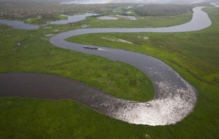
- The calls for the resumption of the Jonglei Canal-by the vocals and non-vocals- is reminiscent of the imperialistic birth of the idea of the Garstin’s cut, later renamed as the Jonglei Canal. There are reasons why the Jonglei Canal project has taken more than a century (1902 to 2022) since it was first proposed; it has always been a sole quest for channelling water to Sudan and Egypt. The call for the resumption of the Jonglei Canal is as good a case of environmental imperialism (Katz 1995) as it was originally proposed in the imperial era. The current or the renewed calls by South Sudanese, official or nonofficial, displays a degree of “turning a blind eye” to the history of the Sudd water resources and the related Jonglei Canal. Such calls are in marked contrast to the trend of the global water dynamics and challenges. The first stage of the project included the digging of a canal to provide approximately 2.4 billion cubic meters of water annually. A second canal was to double this amount, subject to agreement with the countries of the equatorial lakes. By 1984 when the SPLA brought the works to a halt, 240 kilometres of the canal of a total of 360 kilometres had been excavated. (P.P. Howell & J.A. Allan eds. 1996)
- Lastly, these abrupt calls are a staggering display of limited understanding of both the complexity and fragility of the Sudd water resources as well as the threats to Water Security to the population of the Sudd Wetland Region of South Sudan. They demonstrate the failure of conceptualization of the vision for the water resources development and pose potential threats to the future of the country and that of the next generation, considering water resources are a source of livelihoods and a potential catalyst for the economic transformation of South Sudan.
Global context of water challenges.
It is useful to provide a global context for water management challenges. Water Management is at the core of sustainable development and is critical for socio-economic development, energy and food production, healthy ecosystems and for human survival (Water | United Nations). How people use or are affected by water is at the heart of adaptation to climate change, serving as the crucial link between society and the environment. (Water | United Nations).
However, to varying degrees, humans have been grappling with water challenges since the inception of human life. The current and projected trends of global water challenges reflect the complexity of the interplay of water and human systems, their interdependencies and coupled effects, and how they are shaped in time and space (Frontiers in Water). Throughout water-human systems history, the water challenges have been increasingly compounded by growing socio-economic complexity that depends on water resources. As a result, global demand for water is predicted to increase by 55 per cent between 2000 and 2050 (Pacific Institute, 2017). In addition, around two-thirds of the world’s transboundary rivers do not have a cooperative management framework (Stockholm International Water Institute, SIWI). Another challenge is water pollution: currently, over 80 per cent of the world’s wastewater (UNESCO, 2017) is discharged back into rivers, streams, and oceans without any treatment. While the total value of the world’s ecosystem services is estimated at some $147 trillion, over 60 per cent of these are being degraded or used unsustainably (Pacific Institute, 2017).
Water scarcity affects populations of every continent, and it is often exacerbated by the presence of arsenic in groundwater and salinity in surface and groundwater. These factors, among others, are compromising reliable access to the acceptable quantity and quality of water for health, livelihoods, and economic production. Globally, about 3.2 billion people live in agricultural areas with high to very high-water shortages (FAO, 2020). According to the UN data, over two billion people live in countries that are experiencing high water stress. (UN, 2018). Additionally, climate change and variability present a huge amount of uncertainty to water supply reliability in the future. The world is now seeing the increased intensity of water-related natural events. About 90 per cent of natural disasters are weather-related, including floods and droughts (UN International Strategy for Disaster Reduction (UNISDR)). The number of people at risk from floods is projected to hit 1.6 billion in 2050, with $45 trillion worth of assets at risk (World Outlook to 2050: OECD 2012). On the other extreme, it is estimated that by 2050, 3.9 billion people (40 per cent of the world’s population) will live in river basins under severe water stress.
Considering this overview, the current calls for the resumption of the Jonglei Canal Project demonstrate a failure to observe and learn from the global trend of water management challenges compounded by global warming and climatic variability. The Egyptian’s encroachment into South Sudan is evident. It is appearing to have been given blanket mandate to dredge the Nile and provide generators for electric services. It does not take a rocket scientist to see these moves as baits, strategically calculated toward a more than a century goal of exclusive control over how Nile water is utilized. If South Sudan does fall for the bait and the canal is dug, and additional water is flowing to Egypt and Sudan, thus circumventing the Sudd, the VP’s utterance, “we will do it according to South Sudanese terms” carries little value. The primary objective of the Jonglei Canal Project, which has always been to channel the flow of 4.8 billion cubic meters of water annually, to Egypt and Sudan, contrasts with the global trend of water stress. Also, successful implementation of the canal is more likely to pave way for Egypt and perhaps Sudan to undertake similar water channelization initiatives in other areas, such as the swamps of the Bahr el-Ghazal sub-basin and Machar Mashes.
Regional, and Sudd Basin context.
The current population of the Nile Basin is about 257 million of whom at least 50 per cent are heavily dependent on the Nile waters for economic and domestic existence (Nile Basin Initiative, NBI). The rainfall over the basin ranges from virtually zero to over 2000 mm. Considering the current trajectory of the basin population growth, the questions to be addressed are whether these countries will be able to sustain a reasonable degree of food self-sufficiency, or whether they will become increasingly reliant on food imports. As for the hydrological effects on the Sudd, one popular estimation is that one-half of the Bahr el Jebel’s annual discharge of 28 BCM is “lost” annually through evapotranspiration in the Sudd Region (Powell, 2008; Sutcliffe, 1974). In the late 1970s, Douglas H. Johnson did a pioneering study, though interrupted by the civil war, on the reconstruction of the local flood in the upper part of the Sudd Basin. The people now living in the area to the east of the Sudd wetlands, parallel to the proposed Jonglei Canal line “recall major floods and droughts in the nineteenth and twentieth centuries.” (Douglas H. Johnson, 1992). The historical and contemporary sources of the flooding in the basin are multiple and varied, and there is no silver bullet as a panacea for the flooding.
The right thinking or conceptualization of the solutions to the threats of flooding need to consider the uniqueness of the ongoing large scale flooding events.
- These flooding events occur concurrently in multiple areas and sub-regions within the Sudd basin, around the Bahr el Ghazal wetlands, and Machar Mashes.
- The multiplicity of the sources of flooding is apparent: flooding sources include but are not limited to the direction from the west in DRC, CAR and South Sudan border; northeast from Ethiopian Highland, through Baro-Akobo Sobat River sub-system and the confluence with Machar Marshes; east from the Boma Mountains; south from the Lake Victoria, through the Bahr el Jebel; and from local runoffs and torrents.
- The ongoing flooding events can be characterized as large-scale, whose spatial coverage has affected seven of the ten states of South Sudan.
- The levels and depth of the flooding have a unique temporal dimension that is linked to the variability of rainfalls and seasonality; both phenomena are underpinned by impacts of climate change and variability over the equatorial lake countries and the Lake Victoria catchment.
- The scale of the impacts is unprecedented as hundreds of thousands have been displaced, significant destruction of assets such as homes and livestock has been observed.
Alternative interventions categorized on a short-term, medium-term, and long-term basis.
I have been on record since 2008 in my attempt to steer the discourse for the best course of action for strategic and sustainable management of the South Sudan water resources and to inspire the younger generation to embark on studies in various water and environment-related disciplines. I have done this through the publications of my informed perspectives and guidance. This concerted effort on my part began with a written speech I presented to the SPLM Top Leadership at the 2008 SPLM 2nd Convention. The speech highlighted the potential economic power of South Sudan water resources and concerns about the potential effects of the operation of extractive industries on the ecological and environmental conditions in and around the Sudd Basin. A couple of years ago, I wrote an open memo to the President of the Republic of South Sudan on the need for any major physical infrastructure for water management to be preceded by deep scientific research, including future climate scenarios and hydrological modelling. Last year, I was interviewed by the Ramciel Magazine (3rd Edition which featured me on the front cover of the magazine). My conversation with the Ramciel Magazine showcases the role of the Sudd wetlands, a dilemma with the resilience of the populations, and the assessment of potential tipping points in both social and hydrological systems. That conversation concluded with recommendations on what could be done considering the short, medium, and long terms implications of the intersections of both the climate phenomenon and anthropogenic activities.
A few weeks ago, I made a presentation on the South Sudan Political Space- clubhouse, which delved into the drawbacks and advantages of the Jonglei Canal, the uniqueness of the ongoing flooding, and alternative solutions to both water resources management and flood control measure. I was fortunate to have been joined by Hon. Joshua Dau Diu as a discussant who highlighted the historical and political backdrops of the Jonglei Canal and its potential direct implications on the drainage of the Sudd, a change that could potentially lead to desertification of the Sudd Region.
Now that South Sudanese are considering major civil works for flood control and land reclamation and Egypt has reopened discussion about restarting the Jonglei Canal that would allow much of the White Nile flood to bypass the Sudd and be stored behind the High Aswan Dam in Egypt, I have specific recommendations that are on a continuum and are presented here in the ascending order of priorities based on the short-term, medium-term, and long-term categories.
- Short term:
o Phase I: Investment in the relocation program of the most affected populations and communities to higher grounds within the Sudd Basin. The affected populations in Jonglei and the Upper Nile States should evacuate and settle temporarily eastward. Those most affected in Unity State and Lakes State should move to areas and counties that are unaffected or least affected by the flooding.
o Phase I: Investment in the relocation of the most affected populations and communities to other regions and other states that are unaffected by the ongoing large-scale flooding events. The most affected populations in Upper Nile, Unity, and Lakes, Jonglei, Western Bahr el Ghazal states should relocate to other regions and states that are unaffected by the flooding.
o Constructions of higher and safer dykes around key towns, especially in areas and counties that are partially submerged
o Design and construction of minor channelization that pave waterways for the runoffs and torrents and the overflows from the stream inflow.
- Medium-term:
o Phase II: Further investment in the relocation program of the most affected populations and communities to higher grounds within the Sudd Basin. The affected populations in Jonglei and Upper Nile should evacuate and settle semi-permanently eastward if the largescale flooding events persist. Similarly, those most affected in Unity State and Lakes State should move to settle semi-permanently by moving to areas and counties that are unaffected or least affected by the flooding.
o Phase II: Further investment in the relocation of the most affected populations and communities to other regions and other states that are unaffected by the ongoing large-scale flooding events. The most affected populations in Upper Nile, Unity, and Jonglei State, Lakes state should relocate to other regions and states that are unaffected by the flooding.
o Constructions of bigger and safer dikes and embankments to protect towns that are still operational, and which provide services to the populations.
o Expand minor channels strategically to medium or large and longer channelization that connect waterways to outlets and eventually to the main Nile.
o Digging or renovation of the Fula Dam near Nimule, for the regulation of water flow and flood control as well as the utilization of clean electricity from hydropower sources.
o Strategic cultivation and advancement of academic and research knowledge related to water resources– potentially the greatest asset South Sudan has– among younger generations. This should commence with the establishment of national scholarships for students in universities at home and abroad, to study various disciplines that include but are not limited to Climate Science, hydrology, geology, geography, environmental science, pedology, climatology, palaeoclimatology, water engineering, meteorology.
o Establishment of National Water Resources Management Institute (NWRMI) in South Sudan, either by the Act of Parliament or through Executive Order of the President of the Republic of South Sudan.
- Long term:

A hand sketch of South Sudan Potential Water Resources Management (Deng Majok Chol, 2021) Note: This sketch is theoretical, and the recommendations that follow are contingent upon potential hydrological modelling of the Sudd Basin, Bahr el Ghazal Wetland, and the Machar Marshes. Note: Bahr el Arab on this map is the Kiir River.
o Comprehensive plan for South Sudan sustainable water resources management, with the collaboration of multiple institutions: Ministries of Water Resources and Irrigation, Environment, Agriculture and Forestry, Wildlife among other relevant institutions.
o Concerted plans to directly engage the affected local populations and communities, which have historically been victims of intense marginality, in the process of planning and implementation of water resources and flood control research. This approach is necessary to ascertain the inclusion of the populations and communities’ lived experiences through full participation in such studies.
o Digging of water reservoirs and dams in strategic areas that are adjacent to the multiple sources of flooding: one dam in Western Bahr el Ghazal where River Lol, River Jur, and River Pango converge to form the Bahr el Ghazal tributary on its way to the Bahr el Ghazal Wetlands before joining the Bahr el Jebel and Bahr el Zeraf; one dam between Mongalla and Gemeza for both flood control and mechanized agriculture; one dam on the River Sobat near the confluence of Baro and Pibor and Akobo for flow regulation and flood control, and perhaps for hydropower during the rainy seasons with high peaks.
o Construction of artificial Lake in the triangular areas between the Nuer, Dinka, and the Murle in the Jonglei state and Pibor Administrative Area to serve the purposes of water harvest from local rains and runoffs, infiltration, and torrents, thereby controlling the flooding from the rains in the Boma Mountains. The Lake will foster large agricultural schemes and future towns and cities. Other sources of water and flood in Central Equatoria, Jonglei, and Pibor Administration Area can be connected to this artificial Lake through medium and major channelization. To ensure excess water from the Lake does not spill over and inadvertently cause maladaptation, the Lake can be connected to the Pibor River near its junction with the Akobo River.
o And if the large-scale flooding events persist consistently or incrementally for the next 15 to 30 years or are predicted in the future simulation of hydrological and temperature assessment scenarios to last that long, then South Sudan can unpack the discourse of a canal. The right approach should then be a bottom-up which will need to include the affected population in the studies and the need to consider the kind of canals (such as the ring canal) and their operational impacts on the future of the Sudd, Bahr el Ghazal Wetlands, and Machar Marshes, and their natural fragile and complex ecosystems of the human population, biodiversity and wildlife. The conceptual ring canal, shown by two thick green lines on the sketched map, borders the Sudd on both sides along the Sudd permanent boundary lines. The Ring Canal is dynamically seasonal. It would play two diametrical roles depending on the extreme weather events. It is designed to scoop excess spillover water– during the rise of Lake Victoria and Bahr el Jebel water levels– from the permanent Sudd, and channels it to the Nile, thereby preventing spillover and flooding. The ring canal– during the low Nile, when there is no spillover from the Sudd– does not take water, thereby preserving the permanent Sudd, designated as Ramsar Site in 2006 by UNESCO.
o South Sudan to partner with some international scientific research groups from the leading academic institutions to conduct studies and create a flood scale hydrometeorological model of the Upper Nile Basin, and Sudd Basin.
See model output below. Strzepek et al (2021)

Emphasis in conclusion:
- Each and all the alternative major infrastructural interventions, hypothetically and categorically discussed above as long term solutions, will need to be subjected to a series of simulation scenarios and assessments to determine (a) how each of these varying solutions (proposed or conceptual) enhances or detracts resilience of the affected populations, Sudd ecosystem services (biodiversity, wildlife seasonal migration among others), and the socio-economic development of the basins and South Sudan, and (b) how each of the interventions copes with future climate and variability through climatic and hydrological modelling, preferably funded by the Republic of South Sudan in collaboration with independent research groups.
- South Sudanese-led investment in scientific studies, institutions and information should precede any major work on the Sudd Basin, Machar Marshes, and the Bahr el Ghazal wetlands.
- One way to satisfy the insanity of a desire to crash is to jump from the top of the mountain to its foot. Any effort that forces the South to jump from the current position of zero water infrastructure, and skipping short term, medium term, and some feasible long-term solutions, to adopt the largest anthropogenic and technological infrastructure intervention from the colonial era is tantamount to a genocidal action.
- The discourse about the resumption of the Jonglei canal is a huge detraction, a waste of time, and a misplacement of resources for now. Therefore, considering this step-by-step truncated overview, I come as far as recommending that South Sudan stop the futile idea of the Jonglei Canal or any canal project altogether for the next 15 to 20 years, unless hydrological modelling and climatic simulations necessitate such debate.