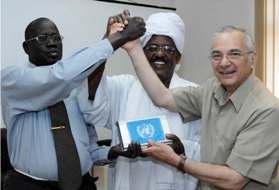
UN provides satellite border mapping system to Sudan
October 20, 2008 (KHARTOUM) – The U.N. mission in Sudan (UNMIS) provided a satellite imagery system to the Sudanese team tasked with producing a border map, one of the key elements of the Comprehensive Peace Agreement (CPA) which ended two decades of civil war in the country.
 The UN Secretary General special envoy to Sudan, Ashraf Qazi presented the equipment, worth $600,000, to the Ad hoc Technical Border Committee – whose 18 members are drawn from both parties to the peace accord – yesterday in the capital Khartoum.
The system will be used to create the map to delineate the 1 January 1956 border, one of the major benchmarks of the 2005 peace agreement.
Next month, a final report, including the map, will be presented to the Presidency. Once it is endorsed, the Committee must proceed with demarcation on the ground.
Qazi congratulated the border Committee, established in 2005, on its vital work and underscored the readiness of UNMIS to assist its work.
Abdallah El Sadig Ali, the border team’s chairman, called the UN’s delivery of the satellite imagery system historic.
(ST)

HONEY
UN provides satellite border mapping system to Sudan
good idea, i want people to know the exact map before seperation. i can’t wait for the Arabs to be left alone in their desert to enjoy peace. also the southerners should be left alone to know what it feels like to dig their oil and sell it to whoever they want.
finish the border maping quickly and thanks for the $600,000 equipment.